Nanadie Project (100%)
(Copper-Gold)
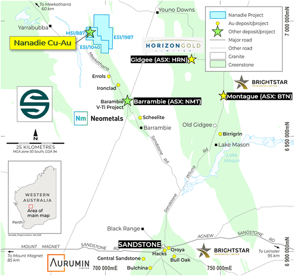
The Nanadie Copper-Gold Project
is located north-east of Sandstone in the Murchison District, Western
Australia. It comprises granted licences M51/887, E51/1040, E51/1987 and
L51/124 and exploration licence application E20/1097 covering a total of 137km2.
Nanadie represents a low cost,
high leverage copper opportunity underpinned by an existing JORC-compliant
Inferred Mineral Resource Estimate (MRE) of 40.4Mt @ 0.4% copper and 0.1g/t
gold for 162kt of contained copper and 130koz gold. The deposit sits in a zone at
least 150m wide by 1km long, extends to surface and remains under-explored at
the margins, depth, and along strike – offering exceptional exploration upside.

The MRE sits within a granted
Mining Lease in a typical flat northern Goldfields setting, with shallow sand
and soil obscuring a geological package dominated by mafic intrusive,
amphibolite and granitoid intrusive rocks.
A recent Phase 1 Reverse
Circulation (RC) has delivered early success, with the first five holes
returning impressive, best-yet drill intercepts that demonstrate the strength
of the Nanadie mineralised system:
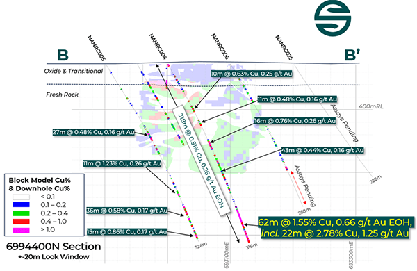
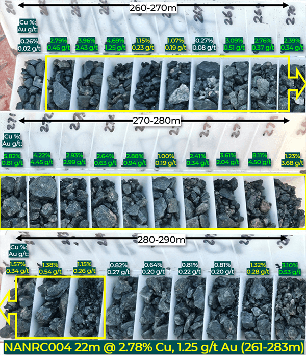
- 62m @ 1.55% Cu, 0.66g/t Au to end of hole (EOH) from 256m (NANRC004), including:
- 22m @ 2.78% Cu, 1.25g/t Au from 261m, plus:
- 10m @ 0.63% Cu, 0.25g/t Au from 80m, 11m @ 0.48% Cu, 0.16g/t Au from 104m, 16m @ 0.76% Cu, 0.26g/t Au from 140m, 43m @ 0.44% Cu, 0.16g/t Au from 166m.
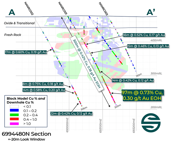
- 97m @ 0.73% Cu, 0.30g/t Au to EOH from 203m (NANRC001), plus:
- 18m @ 0.87% Cu, 0.26g/t Au from 89m, 11m @ 0.58% Cu, 0.13g/t Au from 125m, 14m @ 0.42% Cu, 0.12g/t Au from 178m.
- 27m @ 0.48% Cu, 0.16g/t Au from 119m, 11m @ 1.23% Cu, 0.26g/t Au from 235m, 36m @ 0.58% Cu, 0.17g/t Au from 262m, and 15m @ 0.86% Cu, 0.17g/t Au from 304m (NANRC005)
- 17m @ 0.60% Cu, 0.19g/t Au from 105m, 14m @ 0.58% Cu, 0.20g/t Au from 252m and 22m @ 0.42% Cu, 0.12g/t Au from 272m (NANRC002).

Nanadie Project long section looking west showing the 2022
MRE boundary, all drilling and significant Cu/Au intercepts in limited
step-down diamond drilling to date.
Importantly, the higher-grade
mineralisation of NANRC001, NANRC002, NANRC004, and NANRC005 extends well
beyond the current MRE block model and demonstrate that the system is completely
open at depth and has excellent potential to materially expand on
the current 40.4Mt Mineral Resource Estimate (MRE).
NANRC004 and NANRC001 are
particularly strongly mineralised, with each hole – inclusive of zones of
unmineralised waste – returning 317m @ 0.51% Cu, 0.19g/t Au to EOH, and 300m
@ 0.42% Cu, 0.16g/t Au to EOH respectively.
Copper has a strong demand
outlook, and Solstice is excited by the scale, geometry and MRE growth
potential, and recognises that mafic magmatic systems like these can also
deliver zones of increased grade.


Nanadie Geology
Phase 1 RC drilling, as well as systematic
re-logging of historical drill holes has resulted in increased understanding of
the copper-gold mineralisation and has built a geological picture comprising a
widely mineralised steeply dipping host mafic intrusive (gabbro and dolerite)
package flanked by amphibolite (that is also mineralised in places), and
younger granitoid rocks to the west.
Historical drilling below a
shallow soil and sand cover and ~30m partial weathering profile has defined a
wide, near-surface accumulation of disseminated and remobilised sulphide
veinlet style chalcopyrite (+/- pyrrhotite and pyrite) mineralisation. Approximately
90% of the MRE is fresh rock mineralisation below 40m depth.
Significant zones of >1% Cu
occur where chalcopyrite vein density increases, and increased sulphide veining
is typically accompanied by raised gold values. The fine disseminated and vein sulphide
mineralisation is a style that lends itself to simple float extraction. No
deleterious elements have been noted in available multi-element data, and
Solstice expects that planned sighter metallurgical test work will demonstrate
a commercial concentrate could be produced.

Nanadie Project drill chips from drill hole NANRC004 showing strong Cu and Au mineralisation.